Write your plans in the sand they say. Then sit, and watch them blow away. Old sailing adage. Means make whatever plans you want but the weather is going to be the boss.
We had intended to leave for the BVI after Dawn got back on Wednesday. Had last dinner with neighbors. Returned borrowed GPS. Said last good byes and...... next morning.... 30 knots on the nose... 6-8 foot seas. No go. Christmas winds have come late and stuck around. Its been 20 knots constant with gusts up to high 30s. Seas are going to get to 10 feet. Or as my friend Bob would say... she's blowing stink out there! Were here for a few more days at least.
But, there are certainly worse places to be blown into. We really like it here anyway. Kind of running out of things to do though, and with Paige being home for the next couple of weeks, we don't need the wifi and we were looking forward to getting out and actually doing some sailing.
So we set off to explore more of Puerto Rico. Got the east end down pretty well. Heard about a surf town called Rincon on the west end. Supposed to be laid back, good vibe, like Malibu 30 years ago. Its about as far as you can go to the other end of the island without hitting salt water. So off we go. GPS, (the re-borrowed GPS), says 1 hour 45 minutes. So 3 hours later we arrive. Have I mentioned that driving here is a bit hazardous to ones health? I think I have. Anyway the center of town, which is not quaint at all, is under construction, and it is complete chaos. We finally find our way out to the surf areas. With no help at all from the virtually useless GPS. Nice spot. No waves. They need a north swell and its from the east right now. Had a not very good lunch at a beach bar and wandered into couple of surf shops. Not much there that's for sure. Went to find our hotel. We had reservations in the 5th ranked place in town. Top 4 were booked. Seems the rating scale drops off pretty quick here. It is a not very nice looking place in a not very nice looking neighborhood. Abandoned cars in the next lot over. To far from the beach to walk. To far from town to walk. Safely anyway. Cant even see the water. So we bag the whole plan and set off on another. Didn't even take any pictures of the town to post. Sorry.
So we hit "home" on the GPS and start following the route. Realizing at some point that it is taking us down to the south to get home. The route there was along the north side. No idea why it changed its mind. We didn't use the circumnavigate button! We were going to go to some caves the next day so to try to salvage what we could of the original plan Dawn starts looking for a hotel somewhere near where the caves are. Well, there are none. The caves are in the boonies. But along the south shore... Hilton. Score. Very nice. Great food. Very nice staff. Stayed there the night. They place is owned by the family that owns Don Q rum. A pretty decent local distillery. Happy hour with free rum drinks. They would pour you a bath of it if you asked.
 |
| Here is our "Ocean View" balcony. Look between the railings, just to the right of the center rail, yup, thats it. The ocean. That is literally all you could see of it. But it was a really nice place. Highly recommend it. |
The caves were quite something. Not worth the death ride but quite impressive. Caverns that you could put a 17 story building inside of. 5th largest underground river system in the world. Seemed odd to find that on an island thats 40 by 100 miles.
 |
 |
| Its difficult to capture in a photo. The inside of this was massive. |
 |
| Thought this formation looked like the pirate captain in the Pirates of the Caribbean movies. The guy with octopus tentacles for a face. |
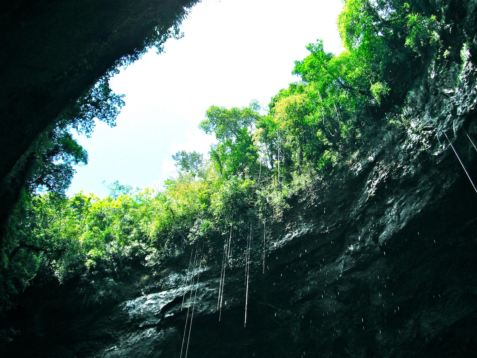 |
| The river is down at the bottom of this sink. Those are tree roots that hang down over a hundred feet. They look like climbing ropes. |
Nice huh? Hey hun, got you something for our aniversary. Some bat poo to rub on your face. Oh yeah, you'll get you some luvin 2 nite fo shur!
All for now. Just waiting on a weather window.
peace
M
Hey thanks for the great recon. Now I know where to go and not go. I think we should get a coupl eof Yam 80's and tackle that South road together! Yoko
ReplyDelete